Boom Town: Rebooting Plan Melbourne
Ideas - by Open Journal
-
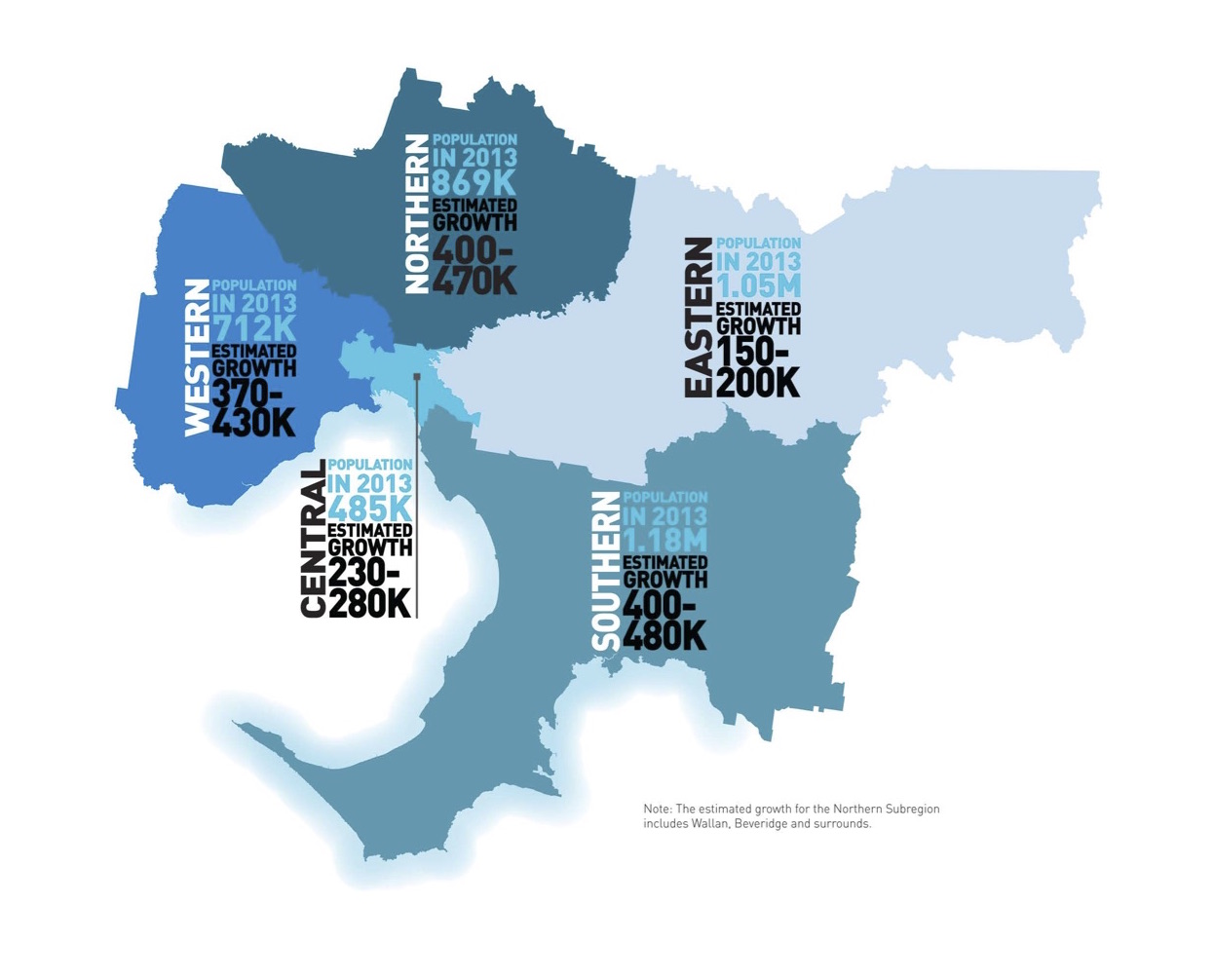
Source: Department of Transport, Planning and Local Infrastructure, 2014
As Melbourne continues to boom, both in population and the construction of new dwellings, it’s difficult to stand back and comprehend how things will look in 35 years. Plan Melbourne, commissioned last year by the previous Napthine government, sought to do just that, predicting how Melbourne will look in 2050 based on current growth, with a list of recommended strategies to consider. In light of the Andrews government recently announcing it will reboot Plan Melbourne, it’s timely that we take a look at this document and its key ideas.
The proposed CBD expansion has identified three suitable areas around the Hoddle grid including Footscray, Parkville and the largest area, the Docklands. This growth zone extends south past Southbank to Montague and continues west towards Wirraway. Put simply, the earmarked area including the Docklands could fit two Hoddle Grids in it, making the west the largest expansion area for Melbourne. Our current CBD spans around 7 square kilometres to Melbourne’s total population of 4 million people, however Plan Melbourne proposes over 20 square kilometres of CBD renewal for some 7.7 million people by 2050. This indicates a plan to continue the rapid residential and commercial growth within the CBD, putting it on a Megalopolis trajectory. The established eastern side of the city has been left off the plan, citing various urban renewal schemes being undertaken by local governments around East Richmond, Collingwood and most notably South Yarra near the South Yarra train station.

Source: Department of Transport, Planning and Local Infrastructure, 2014
That said, the absence in Plan Melbourne to address the converging edge conditions around Melbourne may result in a disconnect between potential high rise concentration to the west and the south eastern borders of the CBD. Given that much of the plan seeks to urbanise industrial land around the Port of Melbourne, Plan Melbourne should be a bolder look at ways to localise these areas rather than see them as an extension of the city grid, as the Docklands has done. If we don’t we may similarly end up with dense volumes of singular residential/ commercial programs incapable of interacting with each other and the greater urban context. A second borough of Melbourne to the west starting from Montague to Wirraway with its own grid would provide an urban pause to counter the eastern fringe, with a sensitive engagement to Williamstown and Port Melbourne. This would be consistent with what Plan Melbourne has tabled for the suburbs, the ’20 minute neighbourhood’.
The 20 minute neighbourhood is the idea that future suburbs will allow residents to access services and facilities within a 20 minute walk. This is especially relevant for Melbourne. Despite the growth proposal for the CBD, the immediate population growth in the Western, Northern & Southern suburbs is expected to double that of the number of people living in Melbourne’s centre by 2031. Plan Melbourne identifies that the 20 minute walk will create more variety of housing choices, however this is followed up with a strategy to protect Melbourne’s suburbs from over densification. Whilst I agree with this, I don’t believe population and pedestrian access should be the only key aspects of creating community.

Source: Department of Transport, Planning and Local Infrastructure, 2014
A conversation about liveable communities should also include the loosening of planning guidelines for housing estate suburbs, particularly with regard to aesthetics. Vibrant architecture through dispersed program within each suburb is equally needed to provide a sense of distinguished neighbourhood character. Rather than isolating houses from the civic hubs, the 20 minute walk can still be achieved through various programs integrating with particular residential areas. Low rise multi storey developments around the centre would facilitate various typologies to better integrate between the zoning overlays within each suburb.
The final area for review beyond the CBD and the suburbs is the fringe. The Hume Corridor for example plans to extend the footprint of affordable housing estates from Craigieburn to Lockerbie potentially being home to one million people by 2050. A growing footprint and population on the edge of Melbourne has implications to the transport network, local agriculture and in the case of the Aurora housing estate in Epping, a case of catch up with the establishment of essential infrastructure services. Whilst Plan Melbourne provides alternative freight routes around the periphery of the city, which in turn offsets the traffic on the Hume and provides better liveability to residents in the North, the bigger question of sustainable growth remains an obstacle yet to properly address. Broader issues around climate change, resource scarcity and increasing inequality continue to have a big impact on Melbourne’s fringe, and it’s important that these ever changing areas are co-ordinated through local and state planning. Whilst Plan Melbourne is a good start, a bolder blueprint with a thorough analysis as to how we might live in 2050 would yield a more exciting and accurate future for Melbourne.
By Jack Dowling

Recent posts